Best Lake Hikes in Colorado

Disclosure: Your use of this site constitutes agreement with our Terms of Use and Purchase, including details regarding affiliate links which may be included in this post.
From the many stunning lakes located within Rocky Mountain National Park to the crystal-clear waters of Ice Lake, Colorado is home to some of the best lakes in the country. After spending over a month exploring Colorado’s trails, I’ve accumulated a list of the best lake hikes in Colorado.
When to Visit Colorado
While hiking in Colorado is possible year-round, the best time to visit for hiking is typically from late summer through early fall. At this time, the weather is generally mild and the snow has melted, making it easier to access trails at higher elevations.
Summer is the peak season for hiking in Colorado, with warm temperatures and sunny skies. However, Fall is also a great time to visit, with the beautiful changing colors of the many aspen trees.
No matter what time of year you choose to visit, be sure to check the weather and trail conditions before setting out on your hike. Additionally, always pack appropriate clothing and gear for the conditions.
Best Lake Hikes in Colorado
1. Blue Lakes Trail
One of the best hikes in Colorado that should be on every hiker’s list is the Blue Lakes Trail. Located in the San Juan Mountains in southwestern Colorado, this trail is known for its beautiful lakes with various vantage points.
The Blue Lakes Trail is a 8.7-mile out-and-back trail that starts at the end of County Road 7 near the town of Ridgway. It’s a pretty rocky, but beautiful, road to get to the trailhead. A high-clearance vehicle would be preferred, but I did see a few sedans in the parking lot. The parking was limited so I’d definitely also recommend heading to the trailhead early.
Hiking the Blue Lakes Trail is not easy but worth the effort. The trail gains about 2,500 feet in elevation, which means you will need to be in decent physical shape. You will also need to be prepared for the change in altitude as this trail tops out at almost 12,000 ft. Make sure to also be prepared for sudden weather changes as parts of this trail is above treeline.
Lower Blue Lake

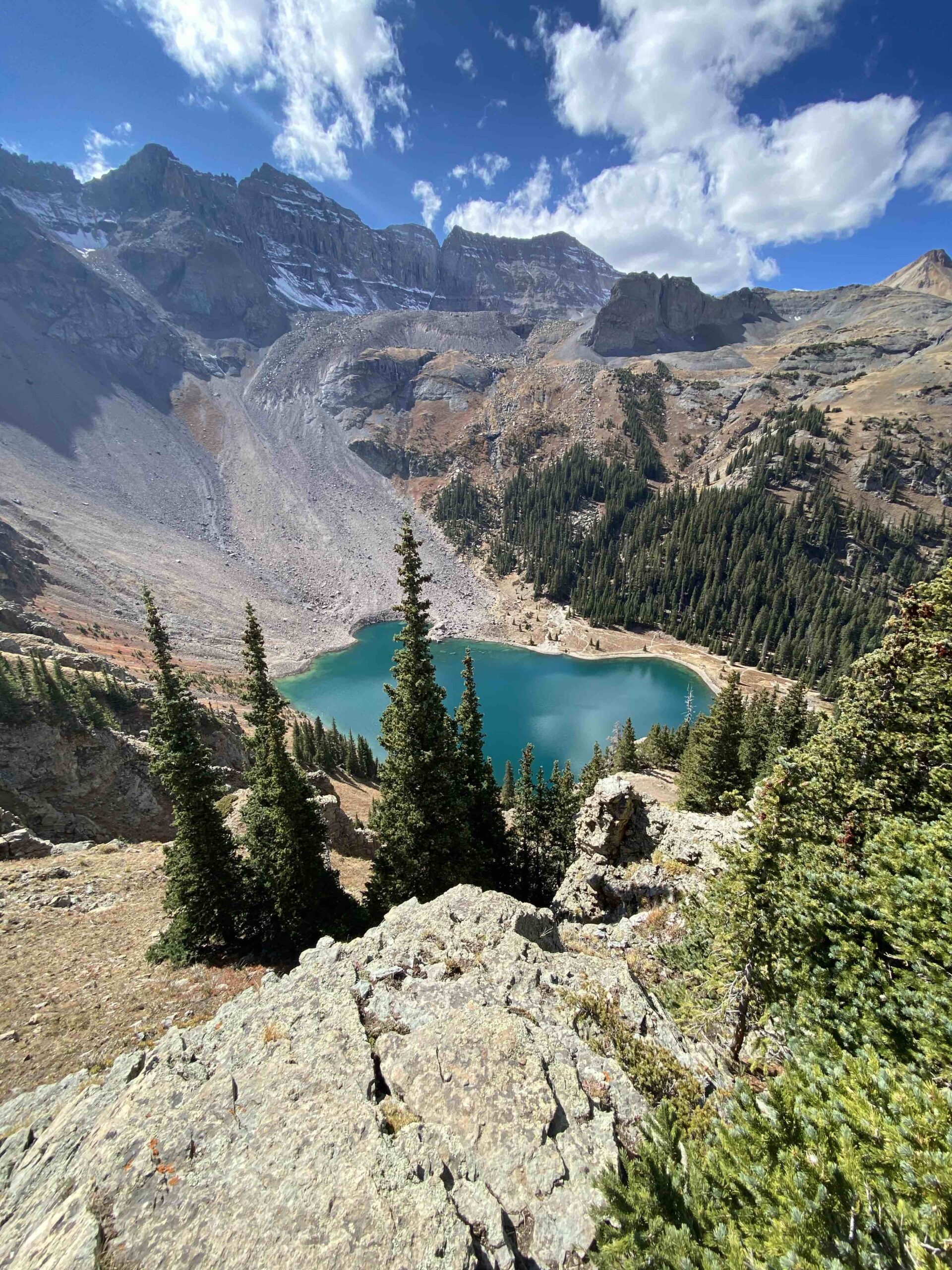
About 3.3 miles into the hike, you will reach Lower Blue Lake, which is an excellent spot to take a break and enjoy the view. The lake is a beautiful turquoise color and is surrounded by towering mountains. From there, the trail continues up to Middle and Upper Blue Lake.
Before reaching Middle Blue Lake, at 3.7 miles in, do not miss the viewpoint of Lower Blue Lake from above. This viewpoint is one of the best views out of all the lake hikes in Colorado.

The trail gets steeper from Lower Blue Lake to the Middle Blue Lake, but if you’re going to cut the trail short, you want to at least make it to this viewpoint.
Middle Blue Lake
4.0 miles in on the hike, you’ll reach Middle Blue Lake. At this point, you will be above treeline. This means the weather can change quickly without appropriate shelter available.
Middle Blue Lake was more windy as it is more exposed, but it was also quieter with less tourists. However, nothing compared to the Lower Blue Lake and it’s viewpoint from above for me.
Upper Blue Lake
4.3 miles in you’ll finally hit Upper Blue Lake. If you start early enough, you can actually continue on to Mt Sneffels. However, this portion of the hike requires a greater level of experience and additional gear.
I would suggest finishing the hike at Upper Blue Lake or at least the viewpoint of Lower Blue Lake. Then, stop for lunch back at Lower Blue Lake on your way down. Lower Blue Lake was warmer, less windy, and very relaxing.
Trail: Lower, Middle and Upper Blue Lakes via Blue Lakes Trail
Length: 8.7 miles
Elevation Gain: 2,509 feet
Route Type: Out & back
Difficulty: HArd
2. The Loch, Lake of Glass, and Sky Pond
Rocky Mountain National Park is one of the most beautiful and popular destinations for hiking in the United States. Among the many trails in the park, one of the best lake hikes in Colorado is Sky Pond. This challenging 8.4 mile round trip hike takes hikers to one of the most spectacular alpine lakes in the park, surrounded by towering peaks.
The trailhead for the Sky Pond hike is located at the Glacier Gorge Trailhead, which is about 12 miles southwest of Estes Park. The Glacier Gorge Trailhead is located off Bear Lake Road. This area of Rocky Mountain National Park requires an advanced timed entry permit to access the park.
The hike begins with a relatively easy 1.8-mile trek along a well-maintained trail that follows a creek fed by Alberta Falls. After reaching Alberta Falls, 0.9 miles in on the trail, the trail becomes steeper and more challenging. You will navigate through a series of switchbacks as you head up the mountain, passing through a beautiful forest of trees.
The Loch
After about 2.9 miles, you will reach The Loch, a beautiful alpine lake with impressive views. This is a good spot to take a break, enjoy the scenery, and recharge for the remainder of the hike. Try to catch it at sunrise. The colors on the mountain behind the lake and the stillness of the water makes this lake so beautiful!

From The Loch, you will continue up the trail to reach Timberline Falls, about 4.2 miles in on the trail. Timberline Falls is a cascade of water that falls down a series of granite steps. This is a challenging section of the trail, as you need navigate up the steep granite steps. It’s a bit of a scramble, but the reward at the top is worth it. Depending on the season, the falls may be icy and microspikes will be extremely helpful to climb up the falls.
Lake of Glass
Right beyond Timberline Falls, you will first reach Lake of Glass. Many mistake Lake of Glass for Sky Pond, but Sky Pond is actually a bit further.

Sky Pond
You’ll need to circle around the right side of Lake of Glass before actually reaching Sky Pond, 4.6 miles in on the trail. Once you finally reach Sky Pond, a picturesque alpine lake surrounded by jagged peaks will be waiting for you. Take a look at the peaks on the right side of the lake. Here you may catch brave climbers summiting a peak named Sharkstooth.

Trail: Sky Pond via Glacier Gorge Trail
Length: 8.6 miles
Elevation Gain: 1,771 feet
Route Type: Out & back
Difficulty: Hard
3. South Boulder Creek Trail
Not only is the South Boulder Creek Trail less than 1.5 hours from Denver, it has so many options for some of the best lake hikes in Colorado. I’d highly recommend visiting in the Fall when the aspen trees are changing colors, especially at the beginning of the trail. Keep a look out for moose on the dirt road to the parking lot as well. I’ve seen moose on this road every time I’ve hiked this trail.
The trailhead for the South Boulder Creek Trail is located at the end of Tolland Rd, which is about 30 miles west of Boulder. The trailhead is easy to find and has plenty of parking.
From the trailhead, you will start on a gradual incline that follows South Boulder Creek. After 2.1 miles, you will come across a junction where you can either take a trail to the right, which leads to the Crater Lakes, or continue straight ahead to Heart Lake.
Heart Lake
The hike to Heart Lake is difficult, with some pretty steep elevation gain up to the lakes. Before reaching Heart Lake, you’ll want to make a stop at Rogers Pass Lake, 4.4 miles in on the trail. I found Rogers Pass Lake to be less windy so I would stop back at this lake for lunch after taking in all the views at Heart Lake.

After another 0.5 miles, you will reach Heart Lake, a beautiful lake in the shape of you guessed it, a heart. If you’ve still got the energy, you can continue up to Rogers Pass to see the shape of Heart Lake from above.
The trail to Heart Lake is mostly shaded, which is perfect for hiking on a hot summer day. However, you should be prepared for changes in altitude and sudden weather changes. It was extremely windy getting up to and at Heart Lake while I was there. The trail is well-maintained and easy to follow, but bring a map and compass in the event of any navigational issues. I did accidentally end up off-trail at one point.
Trail: Heart Lake via South Boulder Creek Trail
Length: 9.6 miles
Elevation Gain: 2,316 ft
Route Type: Out & back
Difficulty: Hard
Crater Lakes Trail
There are 3 different lakes to see on the Crater Lakes Trail. Lower Crater Lake South, Lower Crater Lake North, and Upper Crater Lake. I wouldn’t do this trail without visiting the Upper Crater Lake.
After approximately three miles, you will reach Lower Crater Lake South, a peaceful lake nestled along the trail.

After taking a few photos at Lower Crater Lake South, continue on to Upper Crater Lake. Before the trail starts gaining significant elevation, keep a look out for views of Lower Crater Lake North which you’ll pass on your right hand side.

The trail up to Upper Crater Lake continues up on a steeper incline for the last 0.5 mile. Upper Crater Lake is smaller than the lower lakes, but in my opinion, was more beautiful than Lower Crater Lake North and South. It was absolutely worth the last 0.5 mile gaining 500 ft of elevation.

Trail: Crater Lakes Trail via South Boulder Creek Trail
Length: 7.4 miles
Elevation Gain: 1,870 ft
Route Type: Out & back
Difficulty: Hard
4. Island Lake via Ice Lake Trail
Nestled in a remote area of the San Juan Mountains of southwestern Colorado, the Ice Lake and Island Lake Trail has two of the best lakes in Colorado. This 7.5-mile out-and-back trail takes you through past waterfalls and creeks, a gorgeous valley, and up steeper switchbacks to reach breathtaking alpine lakes, Ice Lake and Island Lake.

The trailhead for the Ice Lake and Island Lake Trail is located approximately 7 miles west of Silverton. The road is rough and bumpy, but any higher clearance vehicle will be fine. The trailhead is well-marked, and there is plenty of parking available.
From the trailhead, you will begin a gradual climb through a dense forest of trees. Then, after approximately one mile, you will reach the first waterfall.
After approximately two miles, you will emerge from the trees into a vast valley filled with wildflowers. The scenery is truly spectacular, with views of the surrounding peaks and the creek below.
As you reach the end of the valley, you will approach several steeper switchbacks that can be challenging. However, at the end of the switchbacks and after approximately 3.2 miles in on the trail, you will reach Ice Lake, one of the most beautifully colored lakes I’ve ever seen. It is truly one of my favorite lakes in Colorado with its vibrant blue-purple color.

For those that want to continue on to Island Lake, the trail continues across a ridge with extremely steep drop-offs, but only for a small portion of the next half-mile.
When I visited Island Lake it had a more blue-green color. However, I’ve seen many posts on social media that show this lake with a more turquoise-ish color. Maybe I just didn’t catch it on its best day.

Make sure you are also prepared for changes in altitude and sudden weather changes when hiking above treeline on this trail.
Trail: Island Lake via Ice Lakes Trail
Length: 7.7 miles
Elevation Gain: 2,680 ft
Route Type: Out & back
Difficulty: Hard
5. Crater Lake – Maroon Bells
The trailhead for the Crater Lake Trail is located just outside of Aspen, Colorado in the heart of the Maroon Bells-Snowmass Wilderness. The Maroon Bells-Snowmass Wilderness does also require an advanced reservation to access the area. I’d highly recommend visiting in the fall when the aspen trees are changing colors throughout the entire trail.
Maroon Lake
The shuttle will drop you off at Maroon Lake which is the best lake on this trail and definitely one of best lakes in Colorado. With its popularity and easy access, there will be many many tourists here. To escape the tourists, continue on the trail to the right of Maroon Lake towards Crater Lake.

Crater Lake
From the trailhead, you will begin a gradual climb through a beautiful forest of aspen trees. The trail is well-maintained and easy to follow, with amazing views of the surrounding peaks throughout the hike. After approximately 1.5 miles, you will emerge from the trees and reach a very rocky area so be sure to watch your footing here.

You will then reach Crater Lake after 1.8 miles on the trail. Crater Lake is smaller than Maroon Lake, but still extremely beautiful with views of the surrounding tree-lined mountain peaks. Keep in mind though, Crater Lake will be mostly dried up in the fall as you can see below. To catch Crater Lake more full, but without the fall foliage, unfortunately, visit in June.

For how to visit this lake without a car, check out this post.
Trail: Crater Lake
Length: 3.5 miles
Elevation Gain: 688 ft
Route Type: Out & back
Difficulty: Moderate
Some of the best lake hikes are located in Colorado and each offers a unique and unforgettable hiking experience. Remember to always practice Leave No Trace principles, respect wildlife, and follow all trail rules and regulations.